Monday, July 10, 2017

mistical


The Skerwink hostel where I stayed on the Bonavista peninsula is feet from the famous Skerwink trail.
It was quite foggy, though the sun burned through in parts. 
The seastacks don't appear to have names. What a missed opportunity in a part of the world that's not shy about language and naming.
 Kind of magical.
 These pinecones are purple.

The seastacks and turquoise water reminded me of Port Orford in southern Oregon. Or hiking in New Zealand.
The total loop is 5.3K, under 4 miles. It's not especially hard, but there are a few sets of steep steps plus mud.

But then you get to the top and it's all worth it.

Spanish moss, making an appearance.


And finally a clear view of historic Trinity and Fort Point lighthouse, whose foghorn I listened to all night. You can see why.
The end winds up in a meadow that could be Pt Reyes (an hour from my house). I earned my brownie.


For more information on the Skerwink trail: from Robinhood bay to Trinity harbor: http://www.theskerwinktrail.com/maps/mainmap.pdf


Sadly, my adventures end here. I'm back in St. John's headed for one last lobster dinner before I fly west. Until the next time.

Sunday, July 9, 2017

the good view


Everyone kept telling me about Bonavista peninsula. Newfoundland (known by locals as The Island but by people in the rest of Canada as The Rock) is fractal in nature, made up of many rocky peninsulas and bays. Twilingate was one of those long arms. Bonvista is another.


Predictably, I loved this story on "hicksters," hip millennials who are moving back to Newfoundland, some after exile in Alberta or Ontario, and opening trendy cafes and breweries. Bonavista is the next Portland.

I'm at Skerwink hostel, among the best hostels I've stayed at anywhere in the world. (Hopewell, look out!) Gavin and Martha are recent transplants to Newfoundland. True travelers, they've thought of almost everything. All the best conversations, the kind that make a trip meaningful and worthwhile, long after you've gone home, happen around the kitchen table. We stayed up talking late into the night.
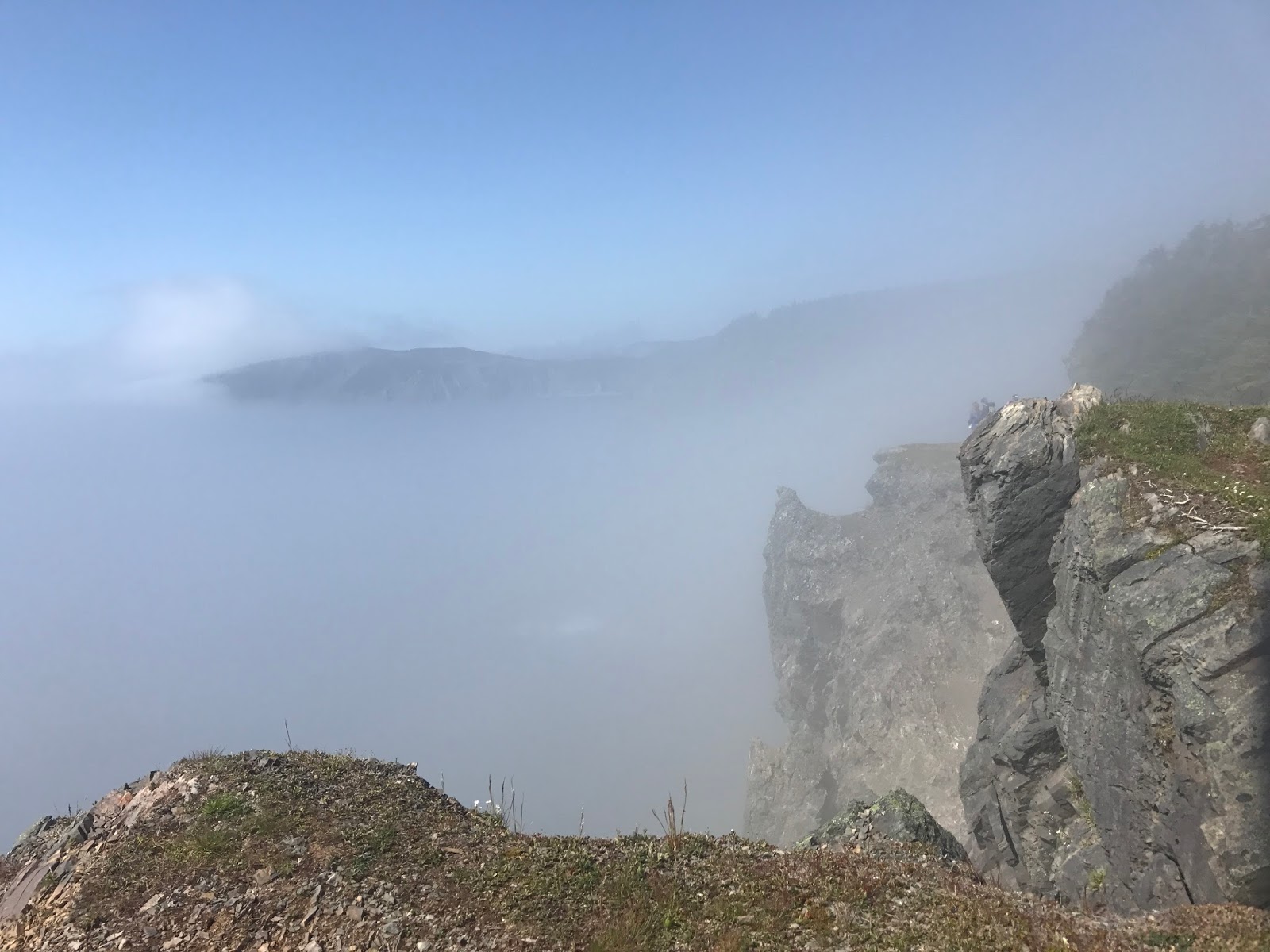
I arrived yesterday after driving six hours in the pouring rain on an occasionally rutted road, with moose warning signs, and thick fog. I awoke the next morning to this:
 It looks a lot like Pt Reyes, or like New Zealand.
After breakfast of homemade bread with five kinds of jam, I headed to Elliston to see the puffins. I'd be warned you needed to go early but it was already close to noon.
It's a pretty area, with dangerous large hidden crevices...but I didn't see any puffins.
Next I drove north to the tip of the peninsula, to Cape Bonavista. 
Nice rocks, eh? And yes, that is an iceberg off in the distance. We're back in iceberg alley.
I watched the black and white and orange birds playing in the turquoise water. I snapped their photos. 
But when I got back and looked at them on a computer, it was obvious these weren't puffins. The couple from New Brunswick did see puffins at the lighthouse--unfortunately one of them was being eaten by a raven.  

On the way back, I stopped in at Port Union, Canada's only town built by a union. I thought it looked like a movie set. Newfoundland has a thriving film industry.
These buildings housed the newspaper of the FPU, the fisherman's protective union. We have an old company town in Northern California in Scotia, which was built for lumbermill workers. It never occurred to me that fisherman would have a union--or a rabble-rousing newspaper. Port Union was restored 15 years ago. Bonavista in general has a lot of heritage buildings and sites.

Which is nor surprising considering John Cabot first landed here in 1497. 
Until Newfoundland joined Canada, many locals lived close to the sea, often on small islands. One of the terms of confederation was that Canada would provide health, power, water, and educational services--but they required many residents of remote villages to relocate closer to population centers.

This resettlement era, which extended from the 1950s through the 1980s caused great distress, breaking up communities that had lived in this place for generations. Some moved to St. John's, others to their children in Ontario.

At the brewery I met a local couple, and she said, like many Newfoundlanders I've met, that she'd been away for years, but finally, at long last, she was home.


Saturday, July 8, 2017

tablelands

Gros Morne is one of the few places in the world where the Earth’s mantle is exposed. 
In fact, the theory of tectonic plates was first proven here.  It made me want to learn more about rocks.


You first spy the tablelands from afar, a reddish-brown mesa atop green forests and granite hills with deep, dark lakes and valleys carved from glaciers.


It’s an easy walk to the mouth of the canyon. It reminded me of Haleakala crater in Maui except we were down at the bottom. (My friend Maxim climbed up to the rim of tablelands. I was dizzy just looking at the video he shot.)

Following a creek up the waterfalls to melting snow, I was fascinated by the etchings on the rocks, and the varied colors.
It reminded me of a long-ago hike in the Canadian Rockies, in a valley carved by a glacier near Mt. Edith Cavell, just south of Jasper.


I was surprised at the number of wildflowers and air plants growing in this inhospitable soil. Another hiker told me this was linden. It’s coniferous. Those are tiny pine cones.

After the tablelands, I drove another 10 kilometers to the end of the road, a lush little town on a cove called Trout River. It felt like an Irish fishing village.

I also stopped in to visit this heritage salt box house, where a family of 8 lived beginning in 1898. They didn't have electricity or TV until 1967.

I'd heard capelin would be leaping from the sea, attracting whales and puffins. All I saw was seagulls, but I did eat a plate of pan-fried capelin. Delicious, with none of the guilt associated with yesterday’s moose burger.


Thursday, July 6, 2017

great sombre

Gros Morne National Park is an unusual place: Vikings were here in Western Newfoundland. So was Captain Cook 250 years ago.
Everywhere you go in Newfoundland, you see posters proclaiming In Cod We Trust. They aren't kidding. Fishing was the primary industry until Canada declared the area overfished and regulated cod production in the 1990s.
 The valley of Western Brook Pond was formed by glaciers. The trail goes through marshes (marais) and bogs, rocky beaches and rich forests.

At the end of the trail, about 2 miles in, is a boat tour, It was full, so I didn't go out. That's okay.
There's no road or water access from the nearby sea, the end of the St. Lawrence, so they had to bring the boat in pieces. By helicopter.

Look closely and you'll see the banks of the stream are filled with wild irises.
 No idea what these fluffy blooms are.
So many ferns. The boardwalk is provided to protect the marsh, and your shoes.

I'm staying at a hostel housed in a converted community hospital. It could be spooky, but it's kind of sweet—babies were born here, medicines mixed. Paul's room proclaims he is the Director of Nursing. Downstairs is a library and physical therapists still see patients. Also there's a pirate radio station. Look for a separate post on my design blog about the period equipment.
I ate a moose burger today. I heard it would be delicious, but all I could think of was Bullwinkle.

Tomorrow I'll drive around Bonne Bay and up to the top to see the Tablelands, the first place to prove theories of tectonic plates. The earth's mantle is visible here. There's even a ranger talk, so Melissa won't worry about me.
Here's a glimpse of Rocky Harbour from the end of the road, next to the graveyard. You can see how it earned its name.